


If you’re using AutoCAD Map 3D 2026 and your images no longer align correctly when inserted, the issue may be that Map 3D is not reading the associated world files (e.g., .jgw, .tfw, .sdw). This bug — not present in previous versions like Map 3D 2025 — has affected many users who rely on MAPIINSERT to insert georeferenced raster images accurately.
In this guide, we’ll walk you through the most effective fixes to help restore correct image placement.
What’s Changed from Map 3D 2025?
In Map 3D 2025, world files are read automatically during MAPIINSERT, and images align perfectly with your drawing setup — even from a network location. In Map 3D 2026, however, some users find:
-
The image inserts in the wrong location
-
The “World File” option is missing from the Modify Correlation dialog
-
The system displays:
“World file not found or not valid”
These symptoms indicate that Map 3D is not reading the world file — even when it’s present and named correctly.
Solution 1: Move Files to a Local Drive
Through community testing, it appears that Map 3D 2026 does not reliably read world files from network drives. If you’re inserting images stored on a shared drive or mapped network folder, the world file may be silently ignored.
To fix this:
-
Copy both the image file (e.g.,
map_image.jpg) and its matching world file (e.g.,map_image.jgw) to a local folder, such asC:\GIS\Images. -
Open your drawing in Map 3D.
-
Run the
MAPIINSERTcommand. -
Browse to the local path and insert the image again.
Map 3D 2026 fails to read the world file when it’s stored on a network drive, even if the file structure is correct.
If this resolves the issue, you’ve confirmed that Map 3D 2026 has trouble accessing world files via network paths — even when folder permissions are correct.
Solution 2: Verify File Associations and Extensions
Map 3D requires the image and its world file to follow strict naming and extension rules. Even a minor mismatch will cause the software to ignore the world file.
Checklist:
-
The image and world file must have the same base name (e.g.,
map_image.jpgandmap_image.jgw) -
The world file must not have a
.txtextension or be renamed incorrectly -
Use the correct file type combinations:
-
.tif→.tfw -
.jpg→.jgw -
.sid→.sdw
-
[Insert screenshot showing correct and incorrect world file pairings in File Explorer]
Failing to match these formats will prevent Map 3D from reading geolocation data, and you’ll be left inserting images manually.
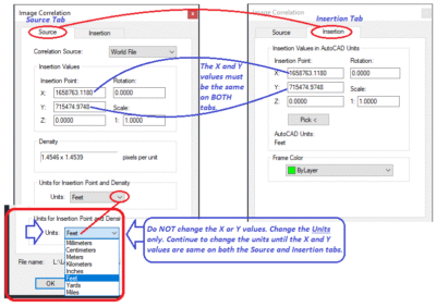
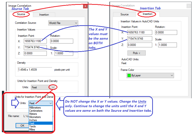
Solution 3: Set Insertion Units and Correlation Source
Even when your world file is valid and local, you may find that the “World File” option is missing from the Modify Correlation dialog during insertion.
To ensure this option appears:
-
Type
UNITSin the command line. -
Set Insertion Scale to Unitless.
-
Use
MAPIINSERTto insert the image. -
In the Modify Correlation dialog, check the Correlation Source field — it should include World File.
The “World File” option is missing from the Modify Correlation dialog — often caused by invalid paths or file naming issues.
If the “World File” option is missing, return to Solution 1 — this is most often caused by Map 3D being unable to locate the world file due to its path.
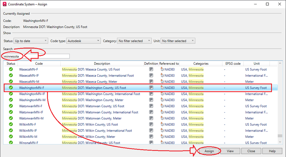
Bonus Tip: Assign a Coordinate System
Although not required in every workflow, assigning a coordinate system can improve accuracy — especially if you work in a shared geospatial environment.
To assign a coordinate system:
-
Run
MAPCSASSIGN. -
Choose the appropriate system for your region or data source.
Still Using Map 3D 2025?
Many professionals choose to purchase AutoCAD Map 3D 2025 licenses for stability and compatibility. If you rely on world file workflows, using a version with known behavior may be more efficient until Autodesk addresses this change.
Related Help
If this guide helped, consider bookmarking it or sharing with your team. Still having issues with image alignment or world file insertion? Leave a comment or contact our support team for direct assistance.